
This is an exploration to achieve higher accuracy in mapping latitude and longitude to a street block. A block is defined as a section of street bounded by one or two other sections of street. The end goal is an abstracted, reusable pattern, but the motivation is to more accurately map trees in New York City to a specific block.
The previous analysis left off by stating that an answer to which block is the most tree lined had been reached, "but how valid is it?" Some inconsistencies were noted, specifically with the block that had the highest reported TPM. Below is the graphic that went along with the statement.
code
library(ggmap)
library(knitr)
library(rjson)
library(dplyr)
library(tidyr)
map.sewardPark <- get_map(location = "40.71597,-73.9889687", zoom = 17, maptype = "toner-lines")
ggmap(map.sewardPark) +
geom_point(data = treeMap[treeMap$blockId == 35,],
aes(x = lon, y = lat, size = stumpDiam), alpha = 0.35, color = "chartreuse") +
scale_size(range = c(5, 7)) +
theme_nothing()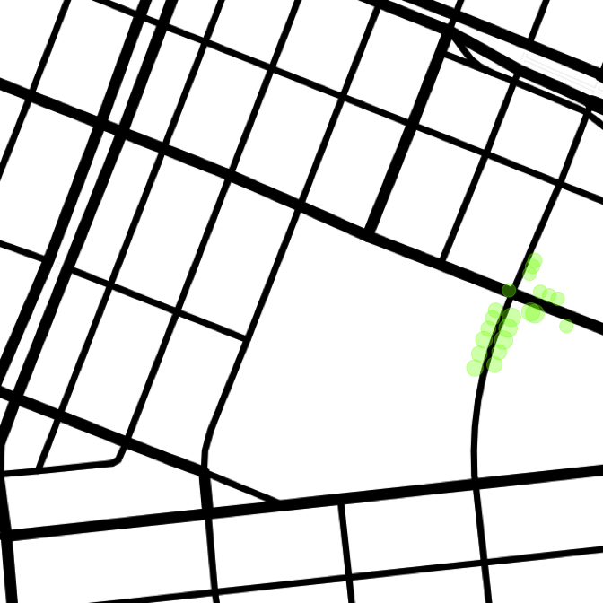
And note that all of these points mapped to the block of Grand b/w Clinton and Suffolk, when most actually lie on Clinton St. The southmost point mapped to this block is at 40.7153009, -73.9871687. That point is reverse geocoded as 410 Grand, with the ArcGIS API1. One alternative is retrieving the full tree data from the Tree Map website. That returns the nearest address as 187 Clinton. Much more accurate, but not extensible. In fact, to emphasize a more general application, the Tree Map data will be subsetted to just a collection of geocoordinates.
points <- treeMap[, c("lat", "lon", "blockId")]Rethinking the question, it's not the exact address that's needed for a given point, just the block it lies on. The Geonames Find Nearby Streets (FNS) API2 proves useful here. In fact, that API provides not only the nearest street, but also the to/from addresses of the segment (JICOC [just in case, of course]). A takeaway from the first analysis is that mixing and matching geocoding services gets messy. In attempt to minimize error, only the Geonames family of APIs will be used.
For the point of interest on Clinton St, here is the result from the FNS call.
code
blocks.35 <- points[points$blockId == 35, ]
user <- readLines("../../geonames.txt")
fns.url <- paste0("http://api.geonames.org/findNearbyStreetsJSON?&username=", user, "&")
fns.parms <- paste0("lat=", blocks.35[order(blocks.35$lat), ][1, "lat"],
                               "&lng=", blocks.35[order(blocks.35$lat), ][1, "lon"])
seg <- fromJSON(file = paste0(fns.url, fns.parms))
seg <- sapply(seg$streetSegment, function(i) c(i$name, i$fraddl, i$fraddr, i$toaddl, i$toaddr,
                                              i$mtfcc, i$zip, i$postalcode, i$distance, i$line))
segments <- seg %>% t %>% as.data.frame(stringsAsFactors = FALSE) %>%
            setNames(c("street",    "fraddl", "fraddr",    "toaddl", "toaddr",     "mtfcc",    "zip",
                       "distance", "line"))
segments[, 1:8]
## street fraddl fraddr toaddl toaddr mtfcc zip distance
## 1 Clinton St 166 167 184 185 S1400 10002 0.01
## 2 S1710 0.035
## 3 Clinton St 186 187 198 197 S1400 10002 0.036
## 4 Grand St 408 411 424 425 S1400 10002 0.082
## 5 Clinton St 140 139 164 165 S1400 10002 0.082
## 6 Grand St 390 389 406 409 S1400 10002 0.082
## 7 S1710 0.1
## 8 S1780 0.101
## 9 Suffolk St 1 2 61 62 S1400 10002 0.104
## 10 Grand St 374 383 388 387 S1400 10002 0.104This useful result set returns the to and from addresses for both sides of the street, as well as the distance from the street (which is how the results are ordered). A final component, not included in the above table, are the coordinate that make up each segment. This is a robust value, and includes not just the coordinates for the start and end of the segment, but points of curvature in between. This allows for drawing a multi-point segment on a map, a useful tool in validation. Plotting these segments results in the following
code
drawLines <- function(lat, lon, maptype){
  fns.parms <- paste0("lat=", lat, "&lng=", lon)
  seg <- fromJSON(file = paste0(fns.url, fns.parms))
  seg <- sapply(seg$streetSegment, function(i) c(i$name, i$fraddl, i$fraddr, i$toaddl, i$toaddr,
                                                i$mtfcc, i$zip, i$postalcode, i$distance, i$line))
  segments <- seg %>% t %>% as.data.frame(stringsAsFactors = FALSE) %>%
              setNames(c("street",    "fraddl", "fraddr",    "toaddl", "toaddr",     "mtfcc",    "zip",
                         "distance", "line"))
  segments$id <- seq_along(segments$street)
  lines.list <- strsplit(segments$line, ",")
  lines <- data.frame()
  for (segment in 1:length(lines.list)){
    lines <- rbind(lines, cbind(segment, lines.list[[segment]]))
  }
  lines$V2 <- as.character(lines$V2)
  lines <- lines %>% separate(V2, c("lon", "lat"), " ") %>%
            mutate(lon = as.numeric(lon), lat = as.numeric(lat))
  # relevel to separate similar color lines
  lines$segment <- factor(lines$segment, levels(lines$segment)[c(3, 6, 7, 2, 8, 9, 1, 5, 4, 10)])
  means <- lines %>% group_by(segment) %>% summarize(lat = mean(lat), lon = mean(lon))
  map <- get_map(location = paste0(lat, ",", lon), zoom = 17, maptype = maptype)
  ggmap(map) +
     geom_line(data = lines, aes(x = lon, y = lat, color = segment), size = 4) +
     theme_nothing() +
     geom_point(data = data.frame(lon = lon, lat = lat), aes(x = lon, y = lat),
                size = 10) +
     geom_point(data = data.frame(lon = lon, lat = lat), aes(x = lon, y = lat),
                size = 8, color = "red") +
     geom_text(data = means, aes(x = lon, y = lat, label = segment), size = 6)
}

drawLines(blocks.35[order(blocks.35$lat), ][1, "lat"], blocks.35[order(blocks.35$lat), ][1, "lon"],
          "toner-lines")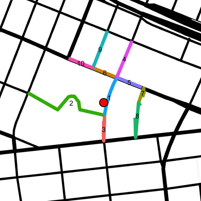
The point of interest is indicated by the red dot, and each segment returned is uniquely colored. The first segment returned is definitely the most correct: Clinton St from 166 - 185. Segment 2 is unwanted, and is actually just a sidewalk from Clinton to Essex. Segment 3 is the other segment that completes this block. Segments 4 - 10 are not part of the block. The task at hand is to create a reproducible process that groups segments 1 and 3 into a block, and eliminates the other results.
The approach involves the previously mentioned Geonames FNS API, as well as the Geonames Find Nearest Intersection (FNI) API. Points are passed to the FNS API, and the segments returned will have their two endpoints passed into an FNI call. The order of rules is as follows:
1) A point's geocoordinates are passed into the FNS API, returning a list of segments.
1) Segments are evaluated in the order of minimal distance from the point. The first segment will act as the reference. Segments may be considered for block inclusion only if their street is the same value as that of the reference.
1) Two calls are made to the FNI API, using the segment's endpoints (first and last coordinates).
2) Endpoints that are within near-0 distance of their nearest intersection are marked as a block end.
2) If the block has two ends, exit the process.
3) If the block has less than two ends, repeat with the remaining segments.
An example with the previous data is as follows: Segment 1 is the reference and an FNI call is made with each of it's endpoints. Two distinct intersections are returned. The distance of segment 1's first endpoint to it's nearest intersection is 0. The distance of the second endpoint to it's nearest intersection is 0.7. Endpoint 1 is added as a block end. The block is still incomplete, process next segment.
The street of segment 2 does not match the reference (segment 1). It's street name is actually an empty string. Skip this segment.
Segment 3 has a matching street name, "Clinton St". FNI calls are made for both endpoints. Distinct endpoints are returned. Endpoint 1 has distance 0.7, and endpoint 2 has distance 0. Endpoint 2 is added as a block end. The block now has two ends and is considered complete. The process exits.
The entire process looks as follows:
code
lines.list <- strsplit(segments$line, ",")
lines <- data.frame()
for (segment in 1:length(lines.list)){
  lines <- rbind(lines, cbind(segment, lines.list[[segment]]))
}
lines$V2 <- as.character(lines$V2)
lines <- lines %>% separate(V2, c("lon", "lat"), " ") %>%
          mutate(lon = as.numeric(lon), lat = as.numeric(lat))

blocks <- data.frame()
tmpBlock <- data.frame()
fni.url <- paste0("http://api.geonames.org/findNearestIntersectionJSON?&username=", user, "&")
primary <- segments[1, "street"]
for (segment in 1 : nrow(segments)) {
  if (segments[segment, "street"] != primary) {
    next
  }
  fni.parms1 <- paste0("lat=", lines[lines$segment == segment, "lat"][1],
                       "&lng=", lines[lines$segment == segment, "lon"][1])
  int1 <- fromJSON(file = paste0(fni.url, fni.parms1))
  fni.parms2 <- paste0("lat=", tail(lines[lines$segment == segment, "lat"], 1),
                       "&lng=", tail(lines[lines$segment == segment, "lon"], 1))
  int2 <- fromJSON(file = paste0(fni.url, fni.parms2))

  if (int1$intersection$distance < 0.001) {
    streets <- c(int1$intersection$street1, int1$intersection$street2)
    street <- streets[streets != primary]
    tmpBlock <- rbind(tmpBlock,
                      data.frame(segment, street = street,
                                 lat = int1$intersection$lat, lon = int1$intersection$lng,
                                 stringsAsFactors = FALSE))
  }
  if (int2$intersection$distance < 0.001) {
    streets <- c(int2$intersection$street1, int2$intersection$street2)
    street <- streets[streets != primary]
    tmpBlock <- rbind(tmpBlock,
                      data.frame(segment, street = street,
                                 lat = int2$intersection$lat, lon = int2$intersection$lng,
                                 stringsAsFactors = FALSE))
  }
  if (nrow(tmpBlock) == 2) {
    blocks <- rbind(blocks, cbind(nrow(blocks) + 1, primary, tmpBlock[1, ], tmpBlock[2, ]))
    break
  }
}

names(blocks) <- c("id", "primary.street", "cross1.segment", "cross1.street", "cross1.lat",
                   "cross1.lon", "cross2.segment", "cross2.street", "cross2.lat", "cross2.lon")
blocks
## id primary.street cross1.segment cross1.street cross1.lat cross1.lon
## 1 1 Clinton St 1 Grand St 40.715952 -73.986721
## cross2.segment cross2.street cross2.lat cross2.lon
## 1 3 E Broadway 40.71431 -73.987165The method works well for a single point. The next challenge is iterating through a list of points, checking if they belong to an existing block or if a new block needs to be created. With this process, the FNS API is called for each point and a matching block is created. This ensures accuracy. A less expensive approach may be to create for each block a polygon (ie thin rectangle for a straight-line block) and check if the point lies within.
code
getSegments <- function(lat, lon) {
  fns.parms <- paste0("lat=", lat, "&lng=", lon)
  seg <- fromJSON(file = paste0(fns.url, fns.parms))
  seg <- sapply(seg$streetSegment, function(i) c(i$name, i$fraddl, i$fraddr, i$toaddl, i$toaddr,
                                                i$mtfcc, i$zip, i$postalcode, i$distance, i$line))
  segments <- seg %>% t %>% as.data.frame(stringsAsFactors = FALSE) %>%
              setNames(c("street",    "fraddl", "fraddr",    "toaddl", "toaddr",     "mtfcc",    "zip",
                         "distance", "line"))
  # grab first and last coordinate for each segment
  segments[, c("coord1", "coord2")] <- t(sapply(strsplit(segments$line, ","),
                                                function(z) c(z[1], z[length(z)])))
  segments <- segments %>% separate(coord1, c("lon1", "lat1"), " ") %>%
              separate(coord2, c("lon2", "lat2"), " ")
  segments$id <- seq_along(segments$street)
  segments[, c(1:8, 10:14)]
}
The getSegments function is broken out to find all the nearest segments to a given point. The code to grab the beginning and ending coordinates for a segment is streamlined in an sapply statement. The complete lines are discarded, as can be seen by the absence of column 9 in the final statement.
Another small function, getStreet helps with code reuse.
getStreet <- function(primary, intersection) {
  streets <- c(intersection$street1, intersection$street2)
  street <- streets[streets != primary]
  if (length(street) > 1) {
   street <- paste(street, collapse = " & ")
  }
  street
}
Embedding this whole process within a loop for every point will look like this:
# seed blocks table with correct data types
blocks <- data.frame(id = 1, primary.street = "Clinton St", cross1.segment = 1,
                     cross1.street = "E Broadway", cross1.lat = "40.715952",
                     cross1.lon = "-73.986721", cross2.segment = 1, cross2.street = "Grand St",
                     cross2.lat = "40.715952", cross2.lon = "-73.986721", count = 0,
                     stringsAsFactors = FALSE)
err <- NULL
tmpBlock <- NULL
points$blockId <- NULL
for (point in 1:nrow(points)) {
  segments <- getSegments(points[point, "lat"], points[point, "lon"])
  primary <- segments[1, "street"]
  tmpBlock <- data.frame()
  for (segment in 1 : nrow(segments)) {
    if (segments[segment, "street"] != primary) {
      next
    }
    fni.parms1 <- paste0("lat=", segments[segment, "lat1"],
                         "&lng=", segments[segment, "lon1"])
    int1 <- fromJSON(file = paste0(fni.url, fni.parms1))
    fni.parms2 <- paste0("lat=", segments[segment, "lat2"],
                         "&lng=", segments[segment, "lon2"])
    int2 <- fromJSON(file = paste0(fni.url, fni.parms2))

    if (int1$intersection$distance < 0.001) {
      tmpBlock <- rbind(tmpBlock,
                        data.frame(segment, street = getStreet(primary, int1$intersection),
                                   lat = int1$intersection$lat, lon = int1$intersection$lng,
                                   stringsAsFactors = FALSE))
    }
    if (int2$intersection$distance < 0.001) {
      tmpBlock <- rbind(tmpBlock,
                        data.frame(segment, street = getStreet(primary, int2$intersection),
                                   lat = int2$intersection$lat, lon = int2$intersection$lng,
                                   stringsAsFactors = FALSE))
    }
     if (nrow(tmpBlock) == 2) {
       minStreet <- which(tmpBlock$street == min(tmpBlock$street))
       tmpBlock <- cbind(tmpBlock[minStreet, ], tmpBlock[-minStreet, ])
       names(tmpBlock) <- c("cross1.segment", "cross1.street", "cross1.lat", "cross1.lon",
                            "cross2.segment", "cross2.street", "cross2.lat", "cross2.lon")
       break
     } else if (nrow(tmpBlock) > 2) {
       # error caught in the below null check. Usually signifies a block missing some segment
       tmpBlock <- NULL
       break
     }
  }
  if (is.null(tmpBlock$cross1.segment) | is.null(tmpBlock$cross2.segment)) {
    # 2 endpoints were not found in the list of segments. add to error list and go to next poitn
    err <<- c(err, point)
    tmpBlock <- NULL
    next
  }
  x <- inner_join(tmpBlock, blocks,
                  by = c("cross1.lat" = "cross1.lat", "cross1.lon" = "cross1.lon",
                         "cross2.lat" = "cross2.lat", "cross2.lon" = "cross2.lon"))
  if (nrow(x) > 0) {
    # block exists
    blocks[blocks$id == x$id, "count"] <- blocks[blocks$id == x$id, "count"] + 1
    points[point, "blockId"] <- blocks[blocks$id == x$id, "id"]
  } else{
    blocks <- rbind(blocks,
                    cbind(id = nrow(blocks) + 1, primary.street = primary, tmpBlock, count = 1))
    points[point, "blockId"] <- nrow(blocks)
  }
}
Most of the points are successfully mapped to blocks, but the loop errors out on point 985 (more on that later). The errors that are caught look like this:
length(err)## [1] 36errTable <- table(points[err, "street"])
errTable##
## Allen St Attorney St Avenue D Broome St Canal St
## 3 4 3 2 1
## Clinton St Delancey St E 4th St E 4th Walk E 5th St
## 1 3 3 2 11
## E Houston St Essex St Grand St
## 1 1 1Out of the 36 errors recorded, the majority are on E 5th St. Looking at the data, those points lie on a dead-end street which indeed has only a single intersection. How can that be recorded in the data?
drawLines(points[67, "lat"], points[67, "lon"], "toner-lines")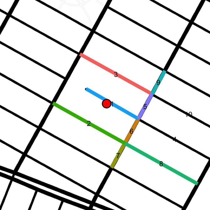
Here is another point that was caught as an error
drawLines(points[462, "lat"], points[462, "lon"])
The FNS API doesn't return segments to complete the full block between Ave A and B. Even with the radius set to the max of 1 km, no additional segments are returned. In both of these cases, the tmpBlock dataframe captures the correct single end from the reference segment. But it also captures both ends of the segment next to it (segment 2 in the above image). This has motivated a fall back option when tmpBlock includes more than 2 block ends. In these cases, the endpoints of the primary segment will be used for both block ends, even though one end does not sit on an intersection. Essentially, the segment is stretched out to the nearest intersection.
For the above point, 462, this means the block is mapped to 4th St b/w A and B. For the 5th St dead-end segment (67), it will be recorded as 5th St b/w B and C. Unfortunately, it's impossible to distinguish between an actual dead-end block and one that simply didn't return it's complete segments. The above two cases look the same from the data point of view. It's only with the actual map underlaid that it can be seen 4th St does indeed intersect with Avenue A, and 5th St doesn't intersect with Avenue B.
In the code, an additional chunk is added to preserve the intersections from the reference segment. If the loop finds more than 2 block ends, it will default to using the intersections nearest the reference segment.
Another addition is a check if minStreet > 1. This handles situations where both block ends are identical, by marking the second one as NA. This was the case for the point that broke the above loop, point 985.
<Interesting digression alert>
Here is the block which threw the error
drawLines(points[985, "lat"], points[985, "lon"], "terrain")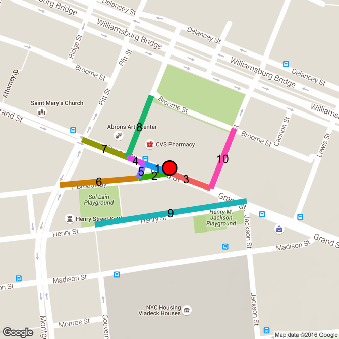
The point is on the north side of Grand St. One of the design choices is to combine both sides of the street. So whether on the north or south, blocks on Grand will be split at Pitt, Bialystoker, East Broadway (1), East Broadway (2), Columbia, Henry/Jackson, Lewis, and Madison. The point lies on the intersection between E Broadway and E Broadway. There is a weird triangle where East Broadway splits into a small west-bound section (5) and a separate east-bound section (2). The block should legitimately be on Grand between E Broadway and E Broadway (segment 1 between segments 5 and 2). This is a rare instance where the same intersection should correctly be used for both block ends.< / Digression>
The added chunks are as follows
code
if (segment == 1) {
      primary.int1 <- int1
      primary.int2 <- int2
    }

###############################

   if (nrow(tmpBlock) > 2) {
       tmpBlock <- rbind(data.frame(1, street = getStreet(primary, primary.int1$intersection),
                                  ...),
                         data.frame(1, street = getStreet(primary, primary.int2$intersection),
                                   ...))
   }

###############################

 minStreet <- which(tmpBlock$street == min(tmpBlock$street))
       if (length(minStreet) > 1) {
         tmpBlock <- cbind(tmpBlock[1, ], "NA", "NA", "NA", "NA")
       }
That method accounts for many of the previous errors. The following blocks were captured that way.
code
prevErrs <- blocks[grepl("&", blocks$cross1.street) | grepl("&", blocks$cross2.street) |
                     grepl("NA", blocks$cross2.street), c(1, 2, 4, 8, 11)]
prevErrs
## id primary.street cross1.street cross2.street count
## 23 6 Pitt St Broome St Samuel Dickstein Plz & Grand St 17
## 48 48 E Houston St Columbia St Lillian Wald Dr & Baruch Dr 2
## 87 87 Attorney St Stanton St NA 5
## 237 90 E Houston St Ave C & Pitt St Ridge St 4
## 241 101 Essex St Ave A & E Houston St Stanton St 9
## 109 109 Broome St Bialystoker Pl & Abraham Pl Pitt St 1
## 254 133 E Houston St Ave C & Pitt St Sheriff St 9
## 154 154 E 6th St Ave D NA 2
## 273 177 Clinton St Delancey St & Williamsburg Brg Rivington St 2
## 189 189 Staten St Exn Stanton St & Pitt St Stanton St Exn 3
## 295 224 Ave C E 2nd St E Houston St & Pitt St 1
## 299 228 Peretz Sq Ludlow St & E Houston St Orchard St 6
## 2103 235 Abraham Pl Bialystoker Pl & Broome St Grand St 7
## 2441 244 Delancey St S Delancey St & Attorney St Ridge St 2
## 2451 245 Grand St E Broadway NA 3
## 2601 260 Stanton St Bowery & Prince St Chrystie St 3
## 2631 263 Hester St Ludlow St NA 7
## 2641 264 E Broadway Grand St NA 2
## 2721 272 Delancey St S Clinton St NA 2
## 2791 279 E Houston St Ave D & Columbia St Lillian Wald Dr 3
## 2871 287 Columbia St Rivington St NA 1
## 2901 290 Clinton St Rivington St Williamsburg Brg & Delancey St N 1
## 305 305 Lillian Wald Dr E Houston St NA 1
## 315 315 Norfolk St Delancey St NA 1
## 320 320 Delancey St Bowery & Kenmare St Chrystie St 3
## 2137 325 Essex St Grand St Hester St & Ludlow St 1
## 2141 333 1st Ave E 1st St E Houston St & Allen St 1
## 2142 334 E Houston St Columbia St & Ave D Sheriff St 1These 28 blocks account for 100 points. Fortunately, correcting this is a relatively simple process: look up the coordinates (not shown) in a map website and plug the correct cross street directly into the blocks dataframe. For a larger number of blocks, this may be a job for Mechanical Turks3.
The remaining problem-points fell into the catch-all group (err), which now includes only 17 points. The first one looks like this.
drawLines(points[err[1], "lat"], points[err[1], "lon"], "toner-lines")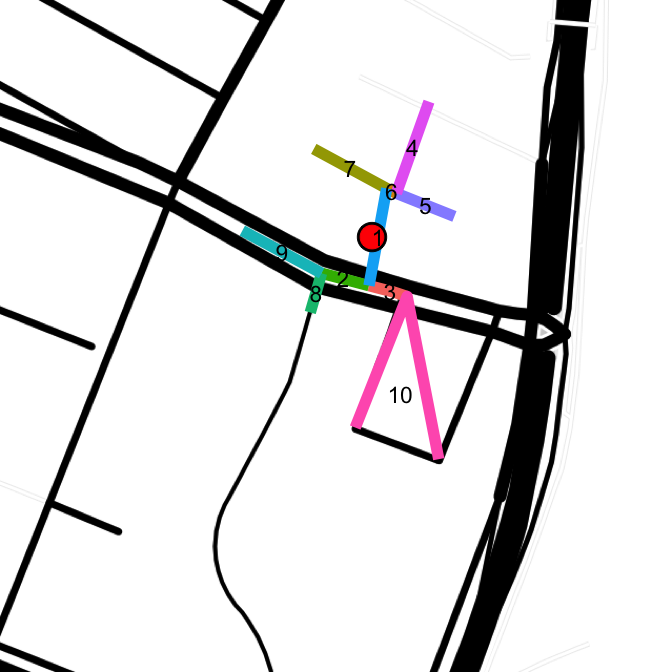
Here, even the map layer fails to capture the actual streets. The first 4 error points lie on Lillian Wald Dr, a block that loops around PS 188. Those streets are made up of segments 1 (roughly), 7 + 6, and a segment parallel to 1 that runs between 5 and 3. An accurate row for these points would have primary street as Lillian Wald Dr, and both cross streets as E Houston St.
Here is a map of all the caught error points.
code
lat.mid <- mean(c(min(points[err, "lat"]), max(points[err, "lat"])))
lon.mid <- mean(c(min(points[err, "lon"]), max(points[err, "lon"])))
map.errs <- get_map(location = paste0(lat.mid, ",", lon.mid), zoom = 15, maptype = "toner-lines")
ggmap(map.errs) +
   geom_point(data = points[err, ],
              aes(x = lon, y = lat), alpha = 0.4, color = "blue", size = 8) +
   theme_nothing()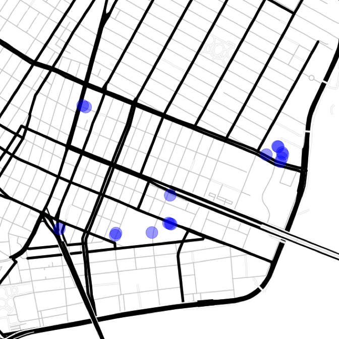
Rather than manually correctly all of these, clustering is used to group points close together, and then the clusters can be manually corrected. That will knock the work down from 17 points to 7 clusters.
code
points.err <- points[err, ]
set.seed(123)
km <- kmeans(cbind(points.err[, "lat"], points.err[, "lon"]), centers = 7, nstart = 50)
points.err$cluster <- as.factor(km$cluster)
ggmap(map.errs) +
   geom_point(data = points.err,
              aes(x = lon, y = lat, color = cluster), alpha = 0.4, size = 8) +
   theme_nothing()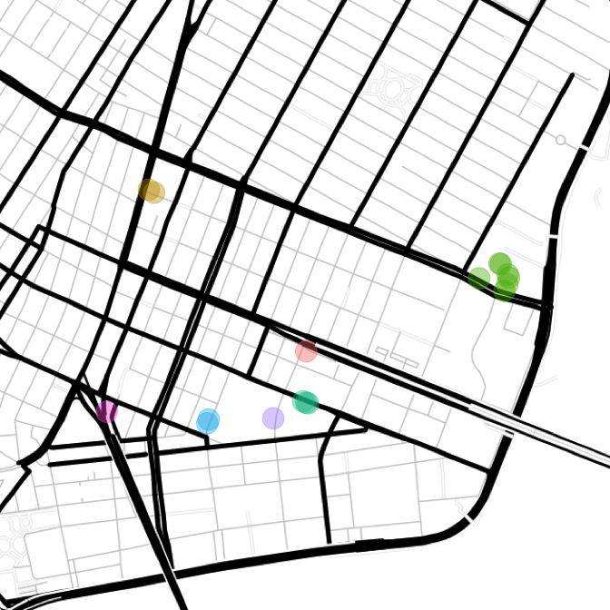
Basic K-means clustering with k = 7 appears to have done the trick. Remember the dark-green cluster is the block of Lillian Wald Dr which loops off Houston. Now 7 blocks will be manually inserted into the blocks table, based on the cluster centers (another good Mechanical Turk/intern task).
km$centers## [,1] [,2]
## 1 40.71730 -73.98577
## 2 40.72277 -73.99273
## 3 40.71987 -73.97699
## 4 40.71556 -73.98579
## 5 40.71491 -73.99019
## 6 40.71501 -73.98725
## 7 40.71524 -73.99475See the corrections file for added blocks. Blocks were inserted and their corresponding points in the original dataframe (points) were mapped back to them.
All the points are now mapped to a block. The main algorithm captured 99.14% of the points (1959) and 98% of the blocks (328). It's up to the user if they want to further correct the prevErr blocks (cross street contained multiple blocks or was missing). I would only correct the blocks that are of interest to the application. In the tree mapping project, if any of those blocks had a high TPM, it would be worth correcting.
ArcGIS REST API: World Geocoding Service
ReverseGeocode returns the closest address to a given lat/lng location
http://developers.arcgis.com/rest/geocode/api-reference/geocoding-reverse-geocode.htm
The Find operation geocodes input and can handle intersections
https://developers.arcgis.com/rest/geocode/api-reference/geocoding-find.htm ↩Geonames Find Nearby Streets (FNS) API
Browser-based map and documentation:
http://www.geonames.org/maps/us-reverse-geocoder.html ↩AWS Mechanical Turk
AWS service that allows users to pay for humans to perform a rote task.
https://aws.amazon.com/documentation/mturk/ ↩